Thursday 11 February 2010

The West Pond

The west pond is a popular resort for the local wildlife, much more popular than the east pond, I have no idea what the difference is, but there must be something to attract the coots, ducks, and swans.

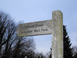
The walk from the remnants of the Antonine Wall is a pleasant one. I pass through and under sparse trees, some totally devoid of leaves looking dead, others green and looking full of life.

The path is un-surfaced and can be very uneven in the best of weather, on a damp and sometimes wet February morning it can be difficult and muddy in places. Always remember to wear sensible boots when doing any walk.

Along one of the old walls that use to surround the estate green moss and ivy grows along its length and down to the leaf strewn path.

I stand and look over the water and see large white shapes raise their wings and pull themselves free from the surface of the pond. Now I hear ducks quacking and I can still hear the gulls overhead. The West Pond is large and trees sprout on the banks and from under the surface of the water. At some point in the past they may have been tall and straight but today some are curved and twisted. The path I am following has tall trees, bare for about 8 or 10 feet from the ground.

Along these paths the local council has placed a number of seats so that I and anybody else who travels this route can rest and enjoy the scenery. Some are made of planks of wood and of more substantial pieces of wood, such as old railway sleepers.

I continue my walk around the West Pond and take in the splendour that is nature. Birds rest on the water and travel in their small groups leaving ‘V’ shaped wakes in their way. Two ducks, with brown feathers, I have no idea of they are male or female, swim around each other and away from me.

The path is soft underfoot and as I travel along it, starts to incline upwards as I head back to the starting point of my journey. The trees are tall and the spring sunlight can be seen through the high branches. Now I come to the end of another little ramble, both on foot and in words I bid you ‘hail and farewell’ and plan my next little adventure.

East Pond and the Antonine Wall

The East Pond of the Kinneil Estate is not large, but is pretty and home to some of the regions wildlife. At this time of year it is not at all colourful, but even in spring nature can be wonderful to look at.

The greens of summer replaced with browns and greys and occasional orange of the trees and bushes.

I don’t hear the local ducks quacking but I can hear the gulls squawking over head and the as I look up on my way to the Antonine Wall I see crows and sparrows swirling and swooping above the trees. I follow the path around the pond and see the area I am heading for.

Not much remains of the Antonine Wall but it is now considered to be Scotland's principal Roman monument. The wall was built around 142 AD at the triumphant end of a military campaign in southern Scotland by the Roman army under the orders of Antoninus Pius, hence ‘Antonine’.

According to the history books it was probably built to strengthen his position as the new emperor of the Roman Empire. Like Hadrian’s Wall, it would have been built to divide the British isle in two. After the death of Antoninus the Roman army withdrew from central Scotland after an occupation of only a little over 20 years, at which time the wall was abandoned, in 162AD, when the Roman legions pulled back to relative safety of Hadrian's Wall, and over time reached an accommodation with the tribes of the area. After a number of attacks in 197 AD, the Emperor Septimius Severus arrived in Scotland in 208 AD to secure the frontier, and repaired parts of the wall. Although this re-occupation only lasted a few years, the wall is sometimes referred to by later Roman historians as the Severan Wall.

The Antonine Wall was a 39 mile (61 kilometers) long barrier built across the narrowest part of central Scotland. It was built of a turf and earthen rampart standing 11feet (3.5 m) in height on a stone foundation on a wooden palisade. About 20 feet (6 meters) to the north of this a substantial V-shaped ditch was dug. This was about 40 feet (12 meters) wide and roughly 14 feet (4.2 meters) deep.

I have no idea how the soldier of the Roman Empire felt being so far from home in such a cold and hostile environment, but looking around from my position at the fortlet I can at least see some of what they saw. The woods may be different, the landscape has changed, but looking out to the River Forth there is still a connection.

Building and people may come and go but a natural feature like the River Forth just runs its way through time and history.

Tuesday 9 February 2010

Kinneil Church

After leaving James Watt's cottage I move onto my next destination.

The next part of the walk takes me towards the ruins of Kinneil Church. This church dates back to the 12th century. At one time it was the centre of a village, no trace remains of that village but some of the church and many of the gravestones still remain for me to see and study.

I cross a small footbridge. Many years ago this stone bridge had only small stones edging the path in order to stop the traveller from falling over. This was replaced by a much higher metal railing during the up grades made by the local council.


As I stand on this foot bridge and look to my left I see a small gully with a river running over flat grey and green stones. The water then falls from a 'step' to another ‘step’ and creates a lovely cascade. This waterfall passes down towards a river that moves under the bridge I now stand on and looking to my right I see the river move and snake its way through, and disappear into, the woods.

I continue my short walk and follow the path around towards the remains of Kinneil Church.

As I approach my destination I get my first peak of the church.

Not much remains now, only the wall that once held the bells, two slots are visible where these bells would have hung. The entrance to the church is still visible, a couple of small stone steps lead down into the body of the ruined building. As I say only one wall remains, but the layout of the church gives you an idea of what would have been. It was not a big church. This church was the centre of a village which no longer remains.

The memory of the village is not lost due to the flat grave stones that are spread about the church ground. Nothing remains of inscriptions due to age, but some engravings can still be made out. As well as erosion by age and weather the inscriptions have also been coated by moss. These stones are wonderful to look at and give some humanity to a piece of history.

Moss covers a lot of the remains.

It is always a thrill to experience something of the past and the past continues as I make my way from the church onto a much older part of the journey.

Next on my list is the East Pond and then onto the Antonine Wall.


Kinneil House and the surrounding area

I know that I have visited this area before, but in this case I am going to look more closely at some of the subjects I have already covered. So please bear with me as I think I am starting to get the hang of this thing now.

I begin my journey at Kinneil Museum. This is a small red roofed building in front of Kinneil House. The museum has an extensive display of the history of the Kinneil Estate.

From the museum I follow the red bales path and head towards the imposing Kinneil House. The oldest part of the house dates back to the late 15th century. It was remodelled in the 16th century and turned into a stately home for the family of the Dukes of Hamilton in the 1660s.

The house has some of the best wall paintings in Scotland. Apparently it also has a ghost. I am sorry to say I did not encounter this ghost, but if I ever do, I will let you know.

The family of the Hamilton’s has a long and distinguished past. One of the best known members was Air Commodore Douglas Douglas-Hamilton, 14th Duke of Hamilton and 11th Duke of Brandon. Sounds posh and he was. His big claim to fame occurred in 1941 when Adolf Hitler’s Deputy Furher, Rudolf Hess flew to Scotland in the mistaken believe that the Duke of Hamilton would be sympathetic to his cause and would arrange a peace treaty between Germany and Britain. He was wrong. And as we know the Second World War lasted until 1945.

As I stand in front of the house, I look to the right of the building and see a wall. In this wall there is a door that is just asking me to go through it, which I do. As I do, I come to a roofless 18th century building. This building was used by the engineer James Watt. Here he carried out early experiments in order to develop the steam engine. He carried these experiments out with his friend John Roebuck, who was leasing Kinneil House at the time.

After looking at the old cottage and soaking in the atmosphere, I head towards the small foot bridge and head towards the next part of the walk.

Friday 5 February 2010

And I can't wait to get on the road again...

Here we go again, another tale of another trail. This one takes us on a slightly more scenic route than around the town and covers some more of the history of Bo’ ness.

I begin my journey as I always do by closing the front door and walking the mile to the town centre. It’s from here I decide which of the routes kindly suggested by the local council pamphlet I will take. On this occasion I will go round the 400 year old harbour, pass the old railway station, and head along the fringes of the River Forth.

I walk down the twisting road and head to my destination.

I cross the small wooded platform that allows access across the railway line and look out over the flat landscape at the river, as I look to the right I see the post office building and the old custom house.

I cross the small bridge and begin following the path around the dock. It has to be said that the dock is not looking at is best at the moment due to the low water level. Mounds and tons of mud and silt undulate inside the walls of the harbour. Small long legged, long beaked birds move over the damp surface looking for food.

The walk along the foreshore is a pleasant one, even at the cold start of a February morning. Ahead of me there are two wooden bench for those who need a rest and want to savour the views of the River Forth. If you stand at the edge of the foreshore and look left you can see up to Grangemouth, every once and a while oil tankers move to and from the massive refinery, breaking through the grey, choppy water.

Straight ahead the far shore of Fife can be seen, looking down to the right, in the distance can be seen the Forth Road and Forth Rail Bridges. Today they are slightly obscured by a light mist.

The foreshore is rocky, no golden sands of a Greek or Spanish beach to enjoy. Today small deposits of snow are scattered over the landscape.

I continue my walk and head towards the Upper Forth Boat Club. There are no boats sitting on the 'runway' today, the water is too low for that, but the yard is full of private boats wrapped up for use. Not far out I can see the white sail of a red boat that has made it's way from the Blackness Boat Club. The two occupants moving back and forth across the boat, doing whatever needs to be done to make it go the way they want it to. As you can probably guess from that last statement, I don't sail, although the idea of 'boating' is something I find interesting.


I move back on myself now and head back through the sparce wood. winter is not kind to these trees. snow still covers the ground but nature is working its magic and returning after the snows of December and January.


In front of me is the harbour that I passed some time ago. near the harbour there is the Bo' ness and Kinneil Railway, part of the Scottish Railway Preservation Society. The SRPC station has a lot to offer, there is a fixed exhibit filling two very large rail sheds, old steam, diesel and electric trains give those who are too young to remember or those who want to relive the golden days of train.

Another experience that the SRPC offers is the power and joy of steam with a 'Day out with Thomas the Tank engine', Easter egg specials, Diesel gala days, Santa steam trains and the traditional Scottish Black bun special.

My journey comes to an end and I prepare to climb the old iron bridge that crosses the railway line.

I hope that I have managed to entertain and educate about the town of Bo' ness, these little journeys will continue and I hope you enjoy them.

Wednesday 3 February 2010

Going places that I have never been, seeing things that I may never see again...

It has been some time since I went for a walk. My last (short) foray was only about 6 or 7 miles, since then my friend Alan and I have been waiting for an opportunity to get together and get a real walk back under our belts again. Previously we had walked in the lovely landscapes of Pitlochry and Callander, both in Perthshire, we have wandered in the countryside of Fife, but nothing really exciting. We have something planned but it's finding a time when we can both spend a full day walking. Also, we needed to get back into a shape other than round.

So the exercises began. The ‘stepping’ up and down the stairs, the walking to and from the town centre rather than the car and the twisting turning, and sit-ups began in earnest.

A plan of mine was to get a bit of exercise by walking out and about around the local area. As you will have seen from my first entry I had a walk and a look around the Kinneil Estate and the ancient Roman Antonine wall. These little ‘build-up’ walks aren’t much, but they help.

First a bit of information about the town, Bo’ ness town first came to prominence as a harbour and then developed into a trading port on the River Forth in days of the sailing ship.

It has been the home to many industries over the centuries such as shipping, coal mining, salt making (well it has to come from somewhere), ship building, and pottery and iron manufacturing. If you look about the streets of Bo’ ness and beyond you will see many drain covers marked with the words ‘Bo’ ness Iron Co’. The current and only iron-works has been in action on its current site since the 1820s.

The old town developed from three main streets, North Street, South Street and the narrow Scotland’s Close, (a Close is a narrow road or passage-way running between buildings) with Waggon (an old spelling and not my typing error) Road following the course taken by wagons transporting coal from the mines to the wharf. The history of mining dates back 900 years to the monastery at Carriden, one of the regions of the area. The last mine closed in the 1980s.

As you enter the town from the west side two things dominate your view, the ‘candle-snuffer’ tower on the former offices of the local newspaper and one of the local pubs, The Anchor Tavern, with its ‘fish-scale’ slated roof.

It may not have the glamour of Edinburgh or Glasgow, or even the near-by Linlithgow (famous birth place of Mary Queen of Scots), but it does have its own special appeal.

Scotland’s Close is a charming little alley way. Standing at the former offices of the local newspaper, to the right are a number of old builds and a renovated building called Dymock’s Building, to the left a there is a renovated 18th century warehouse next to the town library.

Dymock’s Building was built around about 1650 and is one of the oldest in Bo’ ness. It is a former merchant’s house and was restored by the National Trust for Scotland. It is a somewhat unusual colour, orange, but this is not some new fad, it is actually a throw back to the Jacobite colours of the early and middle 1700s. Over the last few years it has been converted into eight apartments.

One of the prominent features of the town centre is the Jubilee Fountain which was given to the ‘towns-folk’ in order to celebrate the Golden Jubilee of Queen Victoria in 1887. It is located on the old Cross Well, this well was one of the original main water supplies for Bo’ ness town.

Another prominent feature is the first purpose built cinema in Scotland, designed by Matthew Steele. It is a fabulous art deco building dating back to 1912. This was used for many years until falling into disrepair, closing for some time and then re-opening to much pomp and celebration after loving restoration work. It has an old, charming feel about it and shows the latest movie extravaganzas as well as cinematic classics, such as Whisky Galore and Gone with the Wind.

In South Street a sandwich shop currently occupies the old Tollbooth, which was built in 1750. Tolls were not popular but had to be paid by hauliers and carriers who had to pay to use the roads. These tolls were abandoned in 1878.

Another feature of South Street is another Matthew Steele designed building, which dates from 1907. Only the upper floors have been renovated to look as originally designed.

As I say these little ‘build-up’ walks aren’t much, but every little helps. My next entry should be a bit more interesting, but I hope you have enjoyed my ‘little wander’.

Friday 27 November 2009

On the road again - Just can't wait to get on the road again.

It has been some time since I have been on a good walk, or indeed a bad walk. Why does work have to get in the way of enjoyment? So, I thought I would break myself back into the walking habit by using one of the local countryside walks that the area offers. It also gave me a chance to learn a bit about the Antonine Wall. The Antonine Wall is the biggest remnant of the Roman Empires occupation of Scotland. Yes, the Roman Empire did indeed make it to Scotland.

This wall was the most northerly boundary of the Roman Empire in Britain. The wall spanned from the River Forth to the River Clyde, a total distance of 37 miles, and was built around about 142AD. There is no need to go far in the Falkirk area to see remaining sections of this historic monument.

In order to celebrate the Millennium, the local council began improving access to the nearly 2000-year-old Roman defences.

The Antonine Wall once stood approximately 10 feet high, the Roman engineers constructing it of turf and earth, this rests on a base of stone.

This particular walk is not a long one; the walk itself covers a distance of 1 mile (approximately 1,500m). The beauty of a walk, any walk is that it does not have to be a hike in order to enjoy the scenery. Also this walk actually starts about 3 miles or so before the history. I live about 3 miles away from its start. So, my 1 mile round trip actually works out as a 7 mile round trip. It's not much but it's a start.

My journey begins at the not very ancient and certainly not Roman car park. I begin my walk and head in a northerly direction towards Kinneil House. This is one of the homes of the Hamilton family, members of the Scottish aristocracy. The house started life as a large 15th century fortified tower.

In the mid-16th century a 'palace' was built to provide more elegant quarters for the family. The building contains several wall paintings on religious subjects which are amongst the finest surviving examples in Scotland.

The path continues towards Kinneil Church, or at least what remains of this historic monument. The path is mostly grass and and is pretty level.

To the right of the path there is a lightly wooded area, sparse now due to the winter months and weather. This path leads towards the East Pond. When reaching the East Pond I turn left and head back onto the grassy path.


Moving around the pond the route leads me past a Roman Fortlet (a small fort) to the left of the path, the Fortlet is marked out by wooden posts. This was also approximately 10 feet high, was originally constructed of turf and earth, and like the wall, rests on a stone base.

Dependant on weather and especially at this time of year the path can be wet and occasionally rough on the feet, but that’s part of the joy of walking, battling the elements, and taking on the landscape even if it is only a mile round trip.

The path continues towards the West Pond, here I encountered a family of swans. All I have to say about swans is, DON'T GET TOO CLOSE! If they feel threatened they start to get noisy and will approach you. Even a small dog decided his barking was not enough to save him. The walk turns left, uphill along the waterside path before turning left down onto a forest track.

Carrying on the path leads past a moderately wooded area finally returning on the gentle uphill slope on the forest track back to the car park.

Here the historical journey ends and my 3 mile walk home begins.